An Other Spatial Scientist acquires, integrates, analyses, interprets, presents, manages and distributes information about locations in space and time, and develops related equipment, software and services.
Occupation description
An Other Spatial Scientist acquires, integrates, analyses, interprets, presents, manages and distributes information about locations in space and time, and develops related equipment, software and services.
Occupations considered suitable under this ANZSCO code:
- Geographic Information Systems Manager
- Geospatial Analyst
Occupations not considered suitable under this ANZSCO code:
- Surveying or Spatial Science Technician
- Cartographer
- Surveyor
- Urban & Regional Planner
- University Lecturer
These occupations are classified elsewhere in ANZSCO or are not at the required skill level.
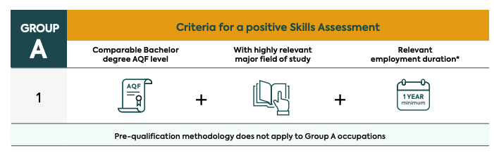
Other Spatial Scientist is a VETASSESS Group A occupation
This occupation requires a qualification assessed as comparable to the educational level of an Australian Qualifications Framework (AQF) Bachelor degree or higher, in a field highly relevant to the nominated occupation. Applicants must also have at least one year of highly relevant, post-qualification employment, at an appropriate skill level completed in the last five years.
** Highly relevant paid employment duration (20 hours or more per week):
One year of post-qualification paid employment (20 hours or more per week) highly relevant to the nominated occupation, at an appropriate skill level in the last five years before the date of application for a Skills Assessment.
Qualification and Employment Criteria
Employment
Highly relevant tasks include, but are not limited to:
- Supervising the preparation of plans, maps, charts and drawings to give pictorial representations and managing spatial information systems.
- Evaluating, compiling and maintaining spatial information using a range of digital and graphical source materials, including aerial photographs, satellite imagery, survey documents, existing maps and records, historical data, reports and statistics.
- Developing and trialing new applications for use in geographic information systems.
- Supervising and coordinating the work of Surveying or Spatial Science Technicians in the production and reproduction of geographic products.
Additional tasks may include:
- Designing or coordinating the development of integrated Geographic Information Systems (GIS) spatial or non-spatial databases.
- Performing geospatial data building, modeling, or analysis using advanced spatial analysis, data manipulation, or cartography software.
- Planning, developing, training and coordinating the use and deployment of GISs.
- Designing or preparing graphic representations of Geographic Information Systems (GIS) data using GIS hardware or software applications.
- Providing technical and analytical support to address issues such as environmental management, exploration and mining, land ownership and titles, urban and regional planning, utilities and asset management, and demographic marketing.
- Reviewing existing or incoming data for currency, accuracy, usefulness, quality, or completeness of documentation.
Employment Information
Other Spatial Scientists are primarily engaged in the development, use and application of Geographic Information Systems (GIS), software solutions and services that are centred on the collation and distribution of geospatial data. Applicants employed in roles suitable for assessment under this occupation may be employed for a wide variety of purposes in a range of different employment contexts - from creation of centralised mapping databases to support utility companies or local councils, through to comprehensive systems employed by governments and non-government organisations to support disaster preparedness, environmental conservation and land management strategies.
Roles with a focus on the performance of technical data acquisition and spatial equipment calibration may be better suited to the alternative ANZSCO occupation of Surveying or Spatial Science Technician. Employment positions with the sole purpose of producing cartographic output or maps may be better suited to the separate ANZSCO occupation of Cartographer. As such, these roles are not considered relevant under this occupation. Additionally, positions undertaken in an academic setting that are focused on teaching, lecturing and supervision of students in the spatial sciences would also not be considered appropriate for assessment under this occupation.
Supporting material for assessment
When applying for a Skills Assessment, please ensure you submit sufficient evidence supporting your proof of identity, qualification and employment claims. A full list of the documents required can be found on the VETASSESS website under Eligibility Criteria.
Get Support
Help with a Skills Assessment
Skills Assessment Support (SAS) services are for migration agents, legal practitioners and prospective applicants who are yet to submit their Skills Assessment application to VETASSESS.
Help with an urgent application
For general and professional occupations, priority processing can be used to fast-track urgent applications
How to apply
If you're a professional choosing to migrate to Australia, chances are you're likely to be assessed by us. We assess 360 different professional occupations, assessing your skills, experience and qualifications.
Find
Find the VETASSESS occupation that most closely fits your skills and experience.
Match
Match your skills and experience to your chosen occupation.
Prepare
Get ready to apply by preparing all the information and documents you need.
Apply
Apply online when you’re ready. If you’re still unsure, skills assessment support is available when you need it.